Guide · Environment and weather
AI in environment and weather
What NOAA, the EPA, the Geological Survey and the Fish and Wildlife Service say they use AI for, where NASA's Earth-science work sits in the same file, and what NOAA's AI order and the EPA's compliance plan say. Counted from the public inventory.
The public record
Federal agencies list their AI use cases each year and OMB compiles them into one public file of 3,611 rows.[3][1] This guide counts four bureaus whose work is the weather, the air and water, the land and the wildlife: NOAA (the Commerce bureau the file names "NOAA"), the EPA (every bureau), and the Interior Department's Geological Survey ("USGS") and Fish and Wildlife Service ("FWS").[1] NASA's Earth science has no bureau of its own in the file, so NASA appears here through a keyword search described below.[1]
How many
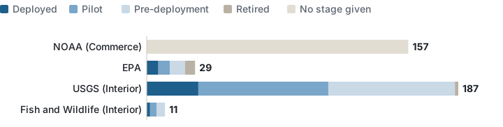
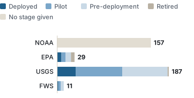
The four bureaus list 384 of the 3,611 use cases: USGS 187, NOAA 157, the EPA 29 and the Fish and Wildlife Service 11.[1] Of the 384, 40 are marked deployed, 89 are pilots, 90 are before deployment and 8 are retired; 157, every NOAA row, carry no stage at all, because NOAA's rows in OMB's file hold only a name and a bureau.[1] Leaving NOAA aside, 18% of the other 227 rows are deployed, against 29% for the whole file, and 2 of the 384 are marked high-impact, both of them the EPA's.[1]
| Bureau, as named in the file | Deployed | Pilot | Pre-deployment | Retired | No stage | Total | High-impact |
|---|---|---|---|---|---|---|---|
| DOC: NOAA | 0 | 0 | 0 | 0 | 157 | 157 | 0 |
| EPA (all bureaus) | 7 | 7 | 9 | 6 | 0 | 29 | 2 |
| DOI: USGS | 31 | 78 | 76 | 2 | 0 | 187 | 0 |
| DOI: FWS | 2 | 4 | 5 | 0 | 0 | 11 | 0 |
| All four bureaus | 40 | 89 | 90 | 8 | 157 | 384 | 2 |
| All 3,611 use cases | 1040 | 440 | 1479 | 314 | 338 | 3611 | 445 |
Data: env-by-bureau-2025.csv
NOAA: names without stages
For NOAA's 157 rows, all a reader gets is the names.[1] They include "AI-Driven Global Forecast Model and Ensemble", "Enhanced Fire Weather, Aviation, and Storm Surge Forecast Guidance", "Evaluate AI Models for Probabilistic Hurricane Predictions", "NWS Public Safety Language Translation", "The Next Generation Fire System (NGFS): Automated human expert-like detection of fires in satellite imagery", and fisheries and marine-mammal tools such as "Automated classification of zooplankton images", "Deep learning algorithms to automate right whale photo id".[1] OMB's README table counts all 223 Commerce rows as deployed or piloted, which the file itself cannot confirm.[3]
Data: env-noaa-rows-2025.csv (every NOAA name)
The Geological Survey and the Fish and Wildlife Service
The Geological Survey's 187 rows are 31 deployed, 78 pilots and 76 before deployment.[1] Science is the topic on 171 of the 227 rows outside NOAA, and classical machine learning the label on 168.[1] The deployed ones include "Automated Walrus Haulout Monitoring [2024 INV#WO0000000110052]", "Evapotranspiration mapping and monitoring", "LANDFIRE", "Machine learning in remote sensing-based wildfire and natural resource risk assessments", "National Land Cover Database (NLCD) [2024 INV#WO0000000107887]", "PRObability of Streamflow PERmanence (PROSPER models) [2024 INV#WO0000000109074]".[1] Of the Fish and Wildlife Service's 11 rows, 9 are pilots or pre-deployment work: wildlife monitoring on refuges, a migratory-bird population estimate, marine wildlife surveys for offshore energy, and permit chatbots and search for ePermits; its 2 deployed rows are "DocketScope" and one row the file leaves unnamed.[1]
| Bureau | Use case, as named in the file | Topic | Type of AI |
|---|---|---|---|
| Fish and Wildlife Service | (no name given) | Law Enforcement | Other |
| Fish and Wildlife Service | DocketScope | Administrative functions | Natural language processing (NLP) |
| USGS | Automated Walrus Haulout Monitoring [2024 INV#WO0000000110052] | Science | Classical ML |
| USGS | Classifying CWD-Infected Elk Using Recurrent Neural Networks on GPS Movement Data | Energy and Environment | Classical ML |
| USGS | Climate Futures for Lizards and Snakes in Western North America [2024 INV#WO0000000109092] | Science | Classical ML |
| USGS | Coastal Change Likelihood: Synthesizing change factors using supervised learning | Science | Classical ML |
| USGS | Deep?learning Integrations into NEIC Operations [2024 INV#WO0000000109496] | Science | Classical ML |
| USGS | Delineating sub-surface drainage using satellite imagery [2024 INV#WO0000000109525] | Science | Classical ML |
| USGS | Effects of vehicle traffic on space use and road crossings of caribou in the Arctic [2024 INV#WO0000000110111] | Science | Classical ML |
| USGS | Estimates of Habitat Suitability of Reed Canarygrass (Phalaris arundinacea) in Upper Mississippi River Floodplain Forest Understories | Science | Classical ML |
| USGS | Evapotranspiration mapping and monitoring | Science | Classical ML |
| USGS | Frog vocalization recognition from digital recordings | Science | Classical ML |
| USGS | Global food-and-water security-support analysis data (GFSAD) project [2024 INV#WO0000000107073] | Science | Classical ML |
| USGS | Invasive Grass Mapping | Science | Classical ML |
| USGS | LANDFIRE | Science | Classical ML |
| USGS | Machine Learning for automatic fracture mapping and rock identification [2024 INV#WO0000000109499] | Science | Classical ML |
| USGS | Machine Learning for Avalanche Frequency Modeling | Science | Classical ML |
| USGS | Machine learning in remote sensing-based wildfire and natural resource risk assessments | Emergency management | Classical ML |
| USGS | National Land Cover Database (NLCD) [2024 INV#WO0000000107887] | Science | Classical ML |
| USGS | Oil Spill Response for Ice-Covered Rivers [2024 INV#WO0000000109142] | Science | Classical ML |
| USGS | Pacific Northwest Stream Flow Permanence [2024 INV#WO0000000109137] | Science | Classical ML |
| USGS | Patterns in the Landscape - Analyses of Cause and Effect | Science | Classical ML |
| USGS | PAWSC Ecotoxicology PFAS Machine Learning [2024 INV#WO0000000112908] | Science | Classical ML |
| USGS | Predicting post-fire tree mortality | Science | Classical ML |
| USGS | PRObability of Streamflow PERmanence (PROSPER models) [2024 INV#WO0000000109074] | Science | Classical ML |
| USGS | Rangeland Condition Monitoring Assessment and Projection (RCMAP) [2024 INV#WO0000000107126] | Science | Classical ML |
| USGS | Seabird and Marine Mammal Surveys Near Potential Renewable Energy Sites Offshore Central and Southern California [2024 INV#WO0000000107535] | Science | Computer vision |
| USGS | Submersed Aquatic Vegetation Vulnerability Evaluation Application (SAVVEA) | Science | Classical ML |
| USGS | Telemetry Analysis Learning Algorithm (TALA) | Other | Classical ML |
| USGS | U.S. Wind Turbine Database | Energy and Environment | Computer vision |
| USGS | use of random forest for species distribution modeling | Science | Classical ML |
| USGS | USGS Flow Photo Explorer [2024 INV#WO0000000109196] | Science | Classical ML |
| USGS | Using Machine Learning in USGS StreamStats to make suspended sediment and bedload predictions [2024 INV#WO0000000107977] | Science | Classical ML |
| EPA | Agency Records Management System | Service Delivery | Classical ML |
| EPA | Helpdesk chat assistant for common data system tasks | IT | Classical ML |
| EPA | Living Literature Review: Semi-automated Literature Screening | Science | Classical ML |
| EPA | Microsoft Power Automate (custom document processing model) | Administrative functions | Classical ML |
| EPA | RCRA PA | Law Enforcement | Classical ML |
| EPA | Streamflow Duration Assessment Modeling | Science | Classical ML |
| EPA | Using machine learning methods to analyze drivers of water quality | Energy and Environment | Classical ML |
Data: env-deployed-2025.csv · env-by-topic-2025.csv · env-by-classification-2025.csv
The EPA
The EPA lists 29 use cases across 8 offices: 7 deployed, 7 pilots, 9 before deployment and 6 retired, all 6 of the retired ones in the Office of Air and Radiation ("OAR").[1] The enforcement office ("OECA") lists 7, among them the set's two high-impact rows, "FFEO TSCA investigation into privatized military housing property management companies", "RCRA PA".[1] The deployed rows include "Streamflow Duration Assessment Modeling", "Using machine learning methods to analyze drivers of water quality" and a records system, a help-desk assistant and a literature screener.[1]
Data: env-epa-by-office-2025.csv · env-high-impact-2025.csv
Weather, water, species, satellite: the words across the file
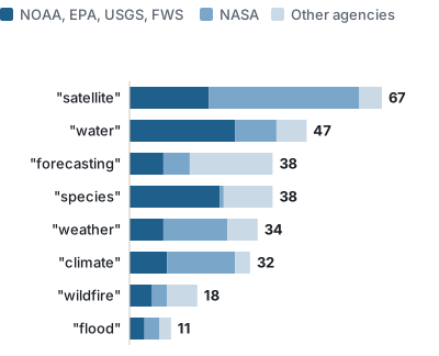
A search of every use case's name and problem statement for weather, climate, forecast, wildfire, flood, air quality, water, species, satellite and Earth observation (whole words, singular and plural, hyphenated compounds such as "satellite-based" included) finds 264 rows.[1] 104 are in the four bureaus and 85 are NASA's, the largest number of any agency; USDA has 29.[1] "satellite" is the word found most often, in 67 rows, 40 of them NASA's; "water" is in 47 and "species" in 38, 24 of those in the four bureaus.[1]
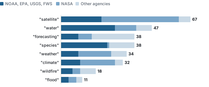
NASA's 85 matching rows include Earth-science work such as "AI Foundation Model for Weather and Climate", "Deep learning for Environmental and Ecological Prediction-eValuation and Insight with Ensembles of Water quality (DEEP-VIEW)", "Development of a machine learning emulator for CAM-CMAQ to improve wildfire smoke forecasts", "Generating localized air quality forecasts for US embassies using ML and GEOS-FP", and rows on astronomy that the word "satellite" also catches.[1] 52 of them are Goddard Space Flight Center's, and 79 of the 85 are before deployment, with 3 deployed.[1] By topic, "Energy and Environment" is a different set again: 131 rows across the file, 41 of them the Tennessee Valley Authority's and 40 the Energy Department's, against 1 for the EPA; that topic is counted in the energy guide.[1]
Data: env-nasa-keyword-rows-2025.csv · env-keywords-by-agency-2025.csv · env-topic-energy-environment-by-agency-2025.csv
What the agencies' own documents say
NOAA's AI policy is an administrative order, NAO 216-128, issued on 16 April 2026; it applies to "all NOAA AI development and use", keeps the NOAA Center for Artificial Intelligence and an AI Executive Committee with "at least one representative from each Line Office", and requires a risk management framework for high-risk use cases and "continuous monitoring and auditing".[4] The center's page describes it as "NOAA's emerging conduit for artificial intelligence", names a Next Generation Fire System that scans GOES satellite imagery for fires, and counts 1,910 community-of-practice members.[5]
The EPA's compliance plan of October 2025 rates the agency at AI maturity level 2 of 5 in a 2022 assessment, says it released an internal generative-AI chat tool in May 2025, and describes the inventory as an annual data call plus continuous submission, with a Data Governance Advisory Committee AI subcommittee deciding which use cases need not be reported, "for example scientific use cases" used for published research.[6]
The earlier version of this site ran three general posts on AI and data science for the environment, now retired.
Counting caveats
- The choice of four bureaus is this site's; the Bureau of Reclamation, the Forest Service (counted under USDA in the agriculture guide) and NASA's centers all do environmental work and are outside the set.[1]
- NOAA's rows carry only a name and a bureau, and Commerce, Education and TVA rows carry no development stage, classification or high-impact mark, so NOAA has no stages, topics, classifications or problem statements here, and the keyword search reaches only NOAA's names.[1]
- The inventory excludes AI used for basic or applied research unless it is meant for agency use, and the EPA says it leaves out research use cases that are not ongoing operational systems; a research model enters the list only once it is meant for operations.[3][6]
- Topic, classification, stage and the high-impact answer are each one choice by the reporting agency.[2]
- Common tasks done with off-the-shelf products go in a separate consolidated file, not in the 384.[3]
See also: AI in agriculture, AI in energy, AI in the public sector, Data science in government, Generative AI in government, and the data story 3,611 uses of AI on the federal list.
Sources
- Office of Management and Budget, 2025 Federal Agency AI Use Case Inventory, file of individually reported use cases (3,611 rows; the repository says "as of April 13, 2026"), counted by this site: 2025_individually_reported_AI_use_cases.csv. Read 28 October 2026.
- Office of Management and Budget, 2025 inventory data dictionary. Read 28 October 2026.
- Office of Management and Budget, 2025 Federal Agency AI Use Case Inventory repository, README (summary, submission schedule and exclusion criteria). Read 28 October 2026.
- National Oceanic and Atmospheric Administration, NAO 216-128, Artificial Intelligence in NOAA, NOAA Administrative Order issued and effective 16 April 2026. Read 29 October 2026.
- National Oceanic and Atmospheric Administration, NOAA Center for Artificial Intelligence (NCAI), the center's page. Read 29 October 2026.
- U.S. Environmental Protection Agency, Compliance Plan for OMB Memorandum M-25-21, October 2025. Read 29 October 2026.
How this page was counted: one row per use case in OMB's file, read on 28 October 2026. A use case is in the set when its agency and bureau columns match one of: DOC with bureau "NOAA"; EPA (every bureau); DOI with bureau "USGS"; DOI with bureau "FWS". The keyword reading takes rows anywhere in the file whose use_case_name or problem_solved contains weather, climate, forecast(s), forecasting, wildfire(s), flood(s), flooding, air quality, water, species, satellite(s) or earth observation(s) as a whole word, case-insensitive (a hyphen is a word boundary, so a hyphenated compound such as "satellite-based" matches); the topic reading takes rows whose topic_area is "Energy and Environment". Stages, topics, classifications and high-impact answers are those columns as given; an empty cell is "no stage given", "no topic given" or "no answer". The CSV files beside this page carry the counts, the source address and the read date; README.txt beside them repeats the rule.