Guide · Mining and critical minerals
AI in mining and critical minerals
Which federal AI use cases name minerals, mines or geology, how much of that is the Geological Survey, what the mine safety regulator lists, and what USGS's minerals program and its annual commodity report say about themselves. Counted from the public inventory with a stated rule.
The public record
Federal agencies list their AI use cases each year and OMB compiles the lists into one public file of 3,611 rows.[3][1] Minerals have no topic of their own in it, and the agencies that deal with them are spread across the file: the Geological Survey, the Bureau of Land Management and the Office of Surface Mining Reclamation and Enforcement at the Department of the Interior, the Mine Safety and Health Administration at the Department of Labor, and the Department of Energy's laboratories, which work on critical materials.[1] So this guide counts rows by what they say, across every agency, and then looks at Interior's bureaus one by one.[1]
The counting rule
A row is counted when its use_case_name or its problem_solved text contains, as a whole word or phrase and ignoring case, "mineral", "minerals", "critical mineral", "rare earth", "mining" followed by industry, environments, operations or safety, "mine safety", "mine site", "mine waste", "mine tailings", "tailings", "mines", "abandoned mine", "coal", "surface" or "underground" followed by "mine", "geologic", "geological" or "geology".[1][2] "Mining" and "mine" on their own are not terms, because in this file they appear in phrases such as data mining and mining a text for content, and "ore" is not, because "ORE" is also an acronym for owned real estate. The rule is a text match: it keeps NASA's geological images of Mars and misses a row about a quarry that uses none of the words. The matched rows are published beside this page with the terms each one matched.[1]
How many, and where
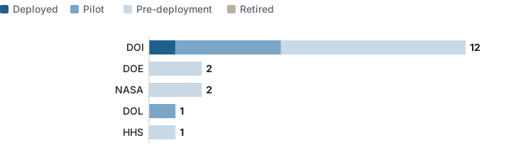
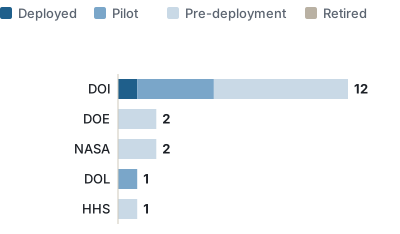
The rule matches 18 of the 3,611 use cases.[1] Of those, 1 is marked deployed, 5 are pilots and 12 are before deployment; none is retired.[1] The Department of the Interior has 12 of the 18, 11 of them from the Geological Survey; the Department of Energy and NASA have 2 each, and the Departments of Labor and Health and Human Services one each.[1] "Mineral" or "minerals" appears in 8 rows, "geologic", "geological" or "geology" in 7, "critical mineral" in 3 and "rare earth" in 1; no row names a coal mine, mine safety or mine waste as such.[1]
| Agency | Bureau | Use case, as named in the file | Stage | Terms matched |
|---|---|---|---|---|
| DOE | NE INL - NE Idaho National Laboratory (NE) | Critical Materials | Pre-deployment | rare earth(s) |
| DOE | NETL - National Energy Technology Laboratory (FECM) | EDX-ClaiMM | Pre-deployment | mineral, minerals; critical mineral(s) |
| DOI | BLM | General Land Office Records Modernization | Pre-deployment | mineral, minerals |
| DOI | USGS | ATLAS | Pre-deployment | mineral, minerals |
| DOI | USGS | ChatGPT to write Python scripts for ArcGIS Pro Maps to be CVD-Friendly | Pre-deployment | geologic, geological, geology |
| DOI | USGS | DARPAs CriticalMAAS | Pilot | mineral, minerals |
| DOI | USGS | Deep Learning application for automated mapping of surficial landforms, surficial geological deposits, and abandoned mine sites from lidar-derived topography | Pilot | mine site(s); abandoned mine(s); geologic, geological, geology |
| DOI | USGS | Determining the resource potential of critical minerals in seafloor massive sulfide deposits | Pre-deployment | mineral, minerals; critical mineral(s) |
| DOI | USGS | Enhancing U.S. critical mineral supply chains through AI and remote sensing mapping of legacy mine sites and tailings | Pre-deployment | mineral, minerals; critical mineral(s); mine site(s); tailings |
| DOI | USGS | Extracting robust, searchable data from narrative geologic descriptions | Pilot | geologic, geological, geology |
| DOI | USGS | Gulf Coast Geologic Energy Machine Learning | Pilot | geologic, geological, geology |
| DOI | USGS | Mineral Resource Assessments | Pre-deployment | mineral, minerals |
| DOI | USGS | National Land Cover Database (NLCD) | Deployed | mineral, minerals |
| DOI | USGS | Zero shot segmentation to expedite Quaternary geologic mapping | Pre-deployment | geologic, geological, geology |
| DOL | MSHA | AI Headset | Pilot | mining industry, environments, operations or safety |
| HHS | HHS/CDC | Mining.AI | Pre-deployment | mining industry, environments, operations or safety |
| NASA | GSFC: Goddard Space Flight Center | System for Uncertainty, Risk, and Feature Assessment of Surfaces (SURFAS) Holistic Scene Analysis | Pre-deployment | geologic, geological, geology |
| NASA | JPL: Jet Propulsion Laboratory | SCOTI (Scientific Captioning of Terrain Images) | Pre-deployment | geologic, geological, geology |
Data: minerals-use-cases-2025.csv · minerals-by-stage-2025.csv · minerals-by-term-2025.csv
What the rows describe
The Geological Survey's rows are the mineral work itself. 3 concern critical minerals: a pilot with DARPA, "DARPAs CriticalMAAS", which finds patterns that "correlate with known mineral deposits" to produce predictive maps; a seafloor model that predicts massive sulfide deposits as critical mineral indicators; and a remote-sensing project to map legacy mine sites and tailings for possible recovery.[1] Beside them are "Mineral Resource Assessments", a literature tool for the assessment workflow, and 5 rows naming geologic work, from Quaternary mapping to shale-well recovery, one of which maps surficial deposits and abandoned mine sites from imagery.[1] The one deployed match is the "National Land Cover Database (NLCD)", whose text lists energy and minerals among its uses.[1] The Bureau of Land Management's match is a records project that reads scanned land documents defining "mineral and lands ownership".[1]
The Department of Energy's 2 are laboratory rows: Idaho National Laboratory's "Critical Materials", which aims to discover combinations of rare earth elements and ligands and is marked high-impact (1 of the 18 matched rows is), and a National Energy Technology Laboratory data platform for the recovery of critical minerals and materials.[1] The Department of Health and Human Services' match is "Mining.AI", a NIOSH chatbot over its mining health and safety research.[1] NASA's 2 are planetary: captioning of rover terrain images and a surface-assessment system, both naming geological features.[1]
Interior and the Geological Survey
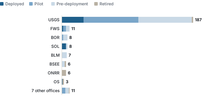
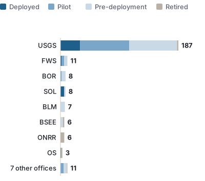
Interior lists 247 use cases, and the Geological Survey 187 of them: 31 deployed, 78 in pilot and 76 before deployment, 165 of the 187 filed under science.[1][2] Only 11 of the 187 match the minerals rule; the rest are water, wildlife, hazards and land-cover science.[1] The Bureau of Land Management lists 7, all before deployment, and the Bureau of Safety and Environmental Enforcement, which regulates offshore oil and gas, 6; the Office of Surface Mining Reclamation and Enforcement does not appear as a bureau in the file.[1]
| Bureau, as named in the file | Deployed | Pilot | Pre-deployment | Retired | Total | Match the minerals rule |
|---|---|---|---|---|---|---|
| USGS | 31 | 78 | 76 | 2 | 187 | 11 |
| FWS | 2 | 4 | 5 | 0 | 11 | 0 |
| BOR | 0 | 2 | 6 | 0 | 8 | 0 |
| SOL | 6 | 0 | 2 | 0 | 8 | 0 |
| BLM | 0 | 0 | 7 | 0 | 7 | 1 |
| BSEE | 0 | 0 | 4 | 2 | 6 | 0 |
| ONRR | 0 | 0 | 0 | 6 | 6 | 0 |
| OS | 1 | 0 | 0 | 2 | 3 | 0 |
| ASIA | 0 | 0 | 2 | 0 | 2 | 0 |
| BTFA | 0 | 2 | 0 | 0 | 2 | 0 |
| NPS | 0 | 0 | 2 | 0 | 2 | 0 |
| OCIO | 0 | 1 | 1 | 0 | 2 | 0 |
| BIA | 0 | 1 | 0 | 0 | 1 | 0 |
| IBC | 0 | 0 | 0 | 1 | 1 | 0 |
| OIG | 0 | 1 | 0 | 0 | 1 | 0 |
The Geological Survey's Mineral Resources Program calls itself "the Nation's primary source of scientific information" on the life cycle and supply chains of mineral resources, and lists its science topics as mineral assessments, supply chain analysis, critical minerals in mine wastes, marine mineral resources, the 2025 list of critical minerals, and minerals and American energy; its news is low-level flights to image geology over eastern California, New Mexico and Nevada.[4] Its annual Mineral Commodity Summaries, which the landing page calls "the earliest Government publication" of nonfuel mineral industry estimates, carries data sheets for over 90 minerals and materials, with a 2026 edition and editions back to 1996.[5] Neither page mentions AI; the mapping and assessment rows above are where the inventory says the Survey applies it.[4][5][1]
Data: usgs-by-topic-2025.csv · interior-by-bureau-2025.csv
The mine safety regulator
The Mine Safety and Health Administration lists 1 use case, a pilot: "AI Headset", a hands-free wearable for inspectors using the agency's inspection application in "mining environments", bought from a vendor and with an operational date in December 2025.[1] MSHA's own site, read on 29 October 2026, lists its rules, data systems and initiatives and does not mention AI.[6]
Data: labor-by-bureau-2025.csv
The earlier version of this site ran three general posts on AI and data science in mines and metals. They are retired; what a federal reader can check is the list above and the pages behind it.
Counting caveats
- The rule is a text match on two fields. "Geological" catches Mars as well as Montana, and a row that describes mining without one of the words is missed.[1]
- AI used for basic or applied research is excluded unless it is meant for agency use, which limits what the Geological Survey and the laboratories list.[3]
- The problem statement is required only for pre-deployment, pilot and deployed use cases, so retired rows can match on their name alone.[2]
- Interior's bureau column names the Survey, Land Management and Reclamation, but Surface Mining Reclamation and Enforcement is absent, so its use cases, if any, are not identifiable.[1]
- Stage, topic and the high-impact answer are each one choice by the reporting agency.[2]
See also: AI in manufacturing, AI in engineering, AI in agriculture, Data science in government, AI in the public sector, and the data story 3,611 uses of AI on the federal list.
Sources
- Office of Management and Budget, 2025 Federal Agency AI Use Case Inventory, file of individually reported use cases (3,611 rows; the repository says "as of April 13, 2026"), counted by this site: 2025_individually_reported_AI_use_cases.csv. Read 28 October 2026.
- Office of Management and Budget, 2025 inventory data dictionary. Read 28 October 2026.
- Office of Management and Budget, 2025 Federal Agency AI Use Case Inventory repository, README (summary, submission schedule and exclusion criteria). Read 28 October 2026.
- U.S. Geological Survey, Mineral Resources Program, program page. Read 29 October 2026.
- U.S. Geological Survey, National Minerals Information Center, Mineral Commodity Summaries, landing page for the annual report (2026 edition and earlier). Read 29 October 2026.
- U.S. Department of Labor, Mine Safety and Health Administration, home page. Read 29 October 2026.
How this page was counted: one row per use case in OMB's file, read on 28 October 2026; a row matches the minerals rule when its use_case_name or problem_solved text contains, as a whole word or phrase and ignoring case, one of the terms listed under "The counting rule" above; no agency is excluded. Interior's bureaus are the agency_bureau column as given for rows whose agency column is exactly "DOI"; the MSHA row is the one whose agency_bureau is exactly "MSHA". Stages, topics, classifications and high-impact answers are those columns as given, with an empty cell counted as "no stage given", "no topic given", "no classification given" or "no answer". The CSV files beside this page carry the counts, the source address and the read date; README.txt beside them repeats the rule in full.